Friday, August 14, 2009

Band of Holes near Pisco Valley, Peru

These strange holes, stretching for a mile over uneven mountain terrain, were here for so long that the local people have no idea who made them, or why. Funny thing is no one really saw the big picture until the area was seen from the air.


Thousands of man-sized holes are carved into the barren rock near Pisco Valley, Peru on a plain called Cajamarquilla.
Click on the image to enlarge.

Satellite photo of the Pisco Valley with marked location of
the "Band of Holes" . Click on the image to enlarge.
Archeologists have speculated they were dug to store grain in. Two problems with this, say the folks thinking out of the box: there were a lot easier ways to create storage containers than the hard work and decades it must have taken to chip out all of these, and it would have made more sense, if these were to store grain, to build several huge chambers.
Ok, said the archeologists. Perhaps they were used as one-person tombs? Vertical graves of some sort? But no bones, artifacts, scraps, inscriptions, jewelry...not even a tooth or strand of hair has been found in them. They have no covers to seal them as you might a tomb and no sacred history or even myth was passed down to label them as such. Some sections have holes in rigid and perfect precision; some run in rows that curve up in arches, some staggered lines. They vary in depth to about 6-7 feet deep yet some are merely shallow indents as if not completed - though surrounded by those that are. To date, no one has a clue why they're here, who made them or what they were.
Satellite photo of the "Band of Holes" near Pisco Valley.
Note: The location of the band of holes is highlighted brown.
Click on the image to enlarge.
Even von Daniken's work begins to take on a realness when one finds an old National Geographic from 1933 corroborating the "Band of Holes," that he personally inspected a few years ago. Each hole is a meter wide and just as deep. There are eight holes spanning 24 meters in width, marching in repetitive uniform fashion, from the Pisco Valley rolling over a mile through mountain terrain -- finally disappearing in the misty mass of Peru. These holes remind this old West Texas boy of the traces left by a massive drilling rig moving along methodically, testing the geology of the Andes for precious metals. Lasers have also left such tracings in the ground. Archaeologists say they represented defensive positions or graves for the ancient ones, except why would you bury anyone on a slope in rocky soil at more than a 45-degree angle? If you look at the most northern part of the band, you will notice that it ends within unnaturally darkened area (it almost looks like a remnants of an explosion)... see the photo below:
Strangely dark area where the "band of holes" ends.
Click to enlarge
Few miles east from the band, satellite photo shows structures that look like a remnants of an ancient settlement (these formations do not look natural and there is nothing similar in the entire area): 13 42'36.80" S, 75 51'4.07" W
Remnants of an ancient city?
Click on the image to enlarge
For the reference here is satellite photo of Machu Picchu:
Ruins of Machu Picchu, Peru (click to enlarge).


Wednesday, August 12, 2009

The Nazca Lines, Peru

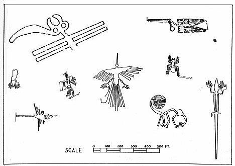
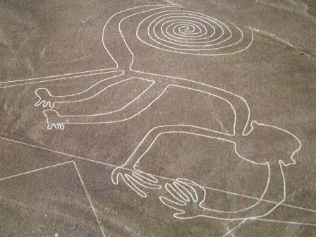
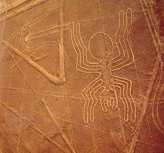
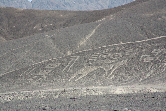
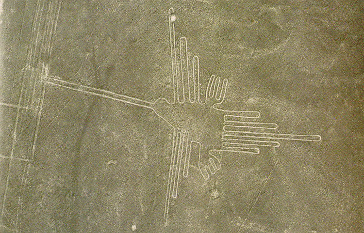
The Nazca Lines are giant sketches drawn in the desert of western Peru by ancient peoples. The drawings were created on such a large scale is such that the shapes can be readily discerned only from the air, leading to a variety of theories about their purpose.
The Nazca Lines were created in the time of the Nazca Indians, who flourished in the area from 200 BC to about 600 AD. Graves and ruins of their settlement have been found near the lines.
The lines would have taken a long time to create, perhaps several generations, and many people contributed to their creation. As to the purpose of the Nazca Lines, see below for some of the theories.
The area of the Peruvian desert in which the Nazca Lines were drawn is called the Pampa Colorada (Red Plain). It is 15 miles wide and runs some 37 miles parallel to the Andes and the Pacific Ocean. The desert is not sandy, but made of dark red surface stones and soil with lighter-colored subsoil beneath. The Lines were created by clearing away the darker upper layer to reveal the lighter subsoil.
It seems incredible that such simply-made drawings have survived for so many hundreds of years, and some have seen a mysterious element to this. But there is also a natural explanation: the surface is made of stone, not sand, and the climate of the area is such that there is practically no erosion. The Nazca peoples chose an excellent place for an enduring monument.
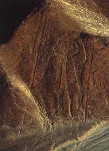
The Nazca Lines include straight lines and geometric shapes as well as stylized depictions of animals, humans and plants. The figures include:
  • monkey
  • condor
  • round-headed, rather friendly-looking human (known as "the astronaut")
  • another human figure
  • spider
  • hummingbird
  • hands
  • tree

Theories of the Nazca Lines mainly attempt to explain why these remarkable drawings were created, and some theories seek to address the "how" question as well. Especially in the earlier years of study, it was difficult for many anthropologists to believe that the ancient Nazca peoples could have created the Lines without help from a more advanced society - or species!
Perhaps the most famous theory of the Nazca Lines is that of Swiss writer Erich von Däniken. In his 1968 book Chariots of the Gods, he suggested that the lines were built by ancient astronauts as a landing field. He identifies the pictures as "signals" and the longer lines as "landing strips."
In 1977, Jim Woodman accepted that the Nazca people made the lines themselves, but puzzled over why they would make them so big that they couldn't even seen them. He hypothesized that the Nazca people used hot-air balloons for "ceremonial flights" to view their creations.
Woodman attempted to demonstrate the validity of his theory by constructing a hot-air balloon out of the materials that would have been available to the Nazca. Using cloth, rope and reeds, Woodman and his colleagues assembled the balloon then risked their lives on a balloon ride that reached a height of 300 feet. The balloon soon descended rapidly; the balloonists bailed out 10 feet above the desert before it crashed some distance away.
In recent years, the professional skeptic Joe Nickell has demonstrated that the drawings would not have been hard to accomplish with only the tools available to the ancient Nazca. Nickell has also shown that although the size of the figures suggests they were intended primarily for the enjoyment of the gods, the drawings can be appreciated from the ground as well.
The general consensus of archaeologists, anthropologists and scientists is that the Nazca Lines were created by the Nazca people themselves, without help from celestial visitors or aerial views. The figures drawn in the desert correspond with images found in other examples of Nazca art, such as pottery.
It is almost certain that the Nazca Lines had a sacred purpose, because: other artifacts of the Nazca culture show a preoccupation with death; other major monuments of the ancient world are known to be ritual in nature; and no plausible practical purpose has yet been discovered.
The Nazca Lines may have been ritual centers for helping the dead achieve immortality; they may have been an offering to the gods; or they could have been a major pilgrimage site.
We may never know why the Nazca peoples put so much time and care into a project that they could barely see. In spite of all that we have learned about them in recent years, the Nazca Lines remain a fascinating mystery.


Thursday, August 6, 2009

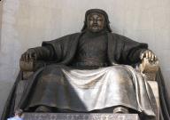
Genghis Khan Tomb

According to legend, Genghis Khan lies buried somewhere beneath the dusty steppe of Northeastern Mongolia, entombed in a spot so secretive that anyone who made the mistake of encountering his funeral procession was executed on the spot.

Once he was below ground, his men brought in horses to trample evidence of his grave, and just to be absolutely sure he would never be found, they diverted a river to flow over their leader's final resting place.

What Khan and his followers couldn't have envisioned was that nearly 800 years after his death, scientists at UC San Diego's Center for Interdisciplinary Science in Art, Architecture and Archaeology (CISA3) would be able to locate his tomb using advanced visualization technologies whose origins can be traced back to the time of the Mongolian emperor himself.

"As outrageous as it might sound, we're looking for the tomb of Genghis Khan," says Dr. Albert Yu-Min Lin, an affiliated researcher for CISA3. "Genghis Khan was one of the most exceptional men in all of history, but his life is too often dismissed as being that of a bloodthirsty warrior. Few people in the West know about his legacy — that he united warring tribes of Mongolia and merged them into one, that he introduced the East to the West making explorations like those of Marco Polo possible, that he tried to create a central world currency, that he introduced a written language to the Mongol people and created bridges that we still use today within the realm of international relations.

"But as great a man he was, there are few clues and no factual evidence about Genghis Khan's burial, which is why we need to start using technology to solve this mystery."

Lin and several colleagues — including Professor Maurizio Seracini, the director of CISA3 and the man behind the search for Leonardo da Vinci's lost "Battle of Anghiari" painting — are hoping to use advanced visualization and analytical technologies available at the California Institute for Telecommunications and Information Technology (Calit2) to pinpoint Khan's tomb and conduct a non-invasive archaeological analysis of the area where he is believed to be buried. Lin plans to work with Seracini to establish a position at UCSD that will allow him to spearhead the three-year Valley of the Khans project, which will require $700,000 in funding for eight researchers (including all expedition costs).

Khan's grave is presumably in a region bordered by Mongolia's Onon River and the Khan khentii mountains near his birthplace in Khentii Aimag, and some experts believe his sons and other family members were later buried beside him. The researchers, however, have little additional information to go on. Directly following Khan's death in 1227, the area around his tomb was deemed forbidden by the emperor's guards, and later in the 20th century, by strict Russian occupation, which prohibited Mongolians from even talking about Genghis Khan because they felt it might lead to nationalist uprising. Only since the 1990s have researchers been allowed in the area, and several other research teams have tried unsuccessfully to locate the tomb.

Lin hopes of success are based on his access to unparalleled technology at Calit2 and CISA3 to pinpoint the area where Khan might have been laid to rest, find the tomb itself and then develop a virtual recreation of it using various methods of spectral and digital imaging.

Explains Lin : "If you have a large burial, that's going to have an impact on the landscape. To find Khan's tomb, we'll be using remote sensing techniques and satellite imagery to take digital pictures of the ground in the surrounding region, which we'll be able to display on Calit2's 287-million pixel HIPerSpace display wall. But we also want to make this an interactive research project and get the public involved. One of our ideas is to utilize something like the International Space Station's 'EarthCam' program at UCSD, which recruits middle school students to control a satellite camera and take pictures of the earth. We'd have them do the same thing, only they'd be taking pictures of the area where Genghis' tomb might be located."

Lin says another approach would be to combine social networking with visualization techniques to replicate something like the online "Find Steve Fossett" project, which enlisted members of the general public to flag anomalous satellite images in the hopes that they could locate the missing adventurer.

"Once we've narrowed down this region in Mongolia to a certain area," Lin continues, "we'll use techniques such as ground penetrating radar, electromagnetic induction and magnetometry to produce non-destructive, non-invasive surveys. We'll then work with people in UCSD's electrical engineering department to develop visual algorithms that will allow us to create a high-resolution, 3-D representation of the site."

Notably, these computer-based technologies are modern evolutions of moveable type and the printing press — innovations that historian Jack Weatherford argues were spread by way of the Mongols as they conquered parts of Europe (Chinese printing technologies predated Gutenberg's printing press by several hundred years). Lin speculates that remnants of those international conquests might even turn up in Khan's tomb, but, he adds, "The process of doing an archaeological dig is up to the Mongolian government."

Lin says he's hoping to collaborate with the Mongolian government and national universities, through the help of Amaraa and Bayarsihan Baljinnayam — siblings from what he endearingly calls his "Mongolian family." They will assist with language interpretation and expedition coordination, and most importantly, local media and political support — connections that will prove very useful as Lin navigates through the often complex arena of international relations.

Noting that his project team also includes San Diego State University Professor of Chemistry and Biochemistry William G. Tong, UCSD Field Systems Engineer Nathan Ricklin, UCSD Computer Vision Engineer Shay Har-Noy and Independent Engineering Geologist Charles Ince, Lin says he sees parallels between the collaborative work he's doing with CISA3 and Genghis' own push to adapt to new technologies.

"He took the best resources of entire world — whether weaponry or medicine -- and adopted those technologies into his own methodology. We're trying to implement that same adaptation to many disciplines into our own work. We're taking the great work that's already been done in archaeology and further developing it by using technologies from other disciplines -- computer vision, social networking, electrical engineering — while at the same time never forgetting fundamentals of historical search.

Despite the technologies and expertise available to him, Lin says he is well aware of the great challenges the project poses. "One consistent fact is that there is no fact," he admits. "It's a story of secrets upon secrets and myths upon myths.

"If I could meet Genghis Khan today, I would ask how he would have wanted to be remembered in history," Lin muses. "The fact that he died in his bed surrounded by people who loved him and never had a single General turn his back on him, the fact that the loyalty of his people is so sound it can be heard across the world — these are the marks of one of the most impressive military heroes of all time. This is an example of a leader who was ruthless, strict, disciplined, and in a lot of ways, extremely honorable. If he was able to rewrite his own history, I wonder how he'd want it heard."

Friday, July 31, 2009

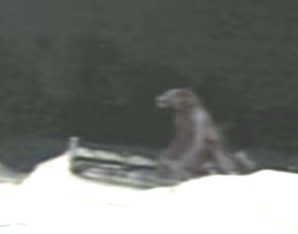
The Michigan Dog Man

In 1987, as an April's Fool's prank, Michigan DJ Jack O'Malley got together with his production director Steve Cook, and made up a song about a half-dog half-man creature that roamed the backwoods of the northern portion of the state.

The creature, which they dubbed the Michigan Dog Man, was created from bits and pieces of creatures from other state legends, including the Bigfoot legend, the legend of the New Jersey Devil, the Boggy Creek Monster, and several other 'cryptids' (animals that appear in legend but heretofore have not been found in nature).

Cook was an avid fan of the paranormal and a student of folklore. The two men came up with a history of the Michigan Dog Man, which included a seven year cycle of appearances. The song played on the radio, the joke was a success, and then the reports started coming in.

But that wasn't the weirdest part.

Turns out there really is an Indian legend unique to the northern part of Michigan about a half-dog, half-man creature that early French explorers claimed to have seen and is referred to in historical texts as the loup garou.The loup garou is a half-man, half-wolf beast that is roughly equivalent to the werewolf of popular fiction and late night horror movies, and was native to the Canadian woodland areas, Michigan, Indiana, and parts of Illinois.

Linda Godfrey, an Elkhart Wisconsin writer, first heard about Dog Man sitings in the greater Chicagoland area, and began to research the phenomenon. Her first book, The Beast of Bray Road, started out as a tongue-in-cheek look at what she assumed would be a totally bogus collection of local lore and dubious anecdotes. However, once Bray got into her research and began interviewing eyewitnesses and collecting evidence, she found herself quickly coverted.

Today, a Dogman blog keeps Dog Man watchers up on the latest sitings, and Bray continues to research and write about what she now believes is an actual creature.

Is there any truth to the legend?

Well, I walk my dog every morning for an hour in a 700 acre nature preserve a mile from my Michigan home. I've never seen the Dog Man there. But I can tell you for sure that the woods in Michigan can be damned spooky, and there have been many mornings when if I had indeed run into a Dog Man, it wouldn't have really surprised me one bit. Seriously.

We are so isolated from nature, most of us, that we really don't 'get it' anymore. So when these legends surface, they become sensational because they are strange to us. For the native peoples of this region, legend and reality were not so sharply separated. They understood that every place also had spirit, and that spirit could change form, or be formless, or invade a human being. Spirit is fluid, shapeshifting. We have no word for that now. We have no concept. 'Legend' is as close as we come, and that's not quite the right word.

Eyewitnesses confirm the shapeshifting quality of the Dog Man, often reporting that at first they thought they were looking at a huge, unnaturally large dog or wolf, but that as they watched, the animal stood on its hind legs and its arms elongated right before their eyes, becoming more humanlike. The Dog Man is often said to have red eyes and a fierce contenance, a detail shared with the New Jersey Devil.

I have a fascination with the paranormal, and the cryptid branch of the paranormal is especially cool. I do believe that there are creatures that inhabit the netherworld between form and spirit, and that can move at will between these worlds.

Is the Michigan Dog Man one of those creatures?

Maybe.

Wanna go for a walk in the woods?


VIDEO

Bizarre animal in Japan

Here is some provocative video of a mysterious creature encountered by Japanese fishermen on a rocky seashore.

The excitement begins when the three men notice a group of strange animals on the side of a nearby cliff. Curious, they approach for a closer look and eventually manage to corner one. (The close encounter begins at 1:45 into the video.)

The slimy, pulsating beast — like something out of a Cronenberg film — appears to be some sort of amphibious sea animal that ventured ashore. After poking and prodding the creature with a stick and flipping it over to reveal an undulating, sphincter-like orifice, one of the men rashly — and unwisely — decides to give it a swig of his carbonated beverage. You don’t want to miss the explosive conclusion.

Is this a bizarre new species? Alien creature? Spectacular hoax? You be the judge.